EWAA Heritage – Colin Gammon looks back…
Did you know that the EWAA grounds have been under cultivation for over 100 years? At the front of the local history books The Changing Faces of Cowley both books 1 & 2, there is a map of the whole area before 1900 which clearly shows our ground as ‘allotment gardens’.
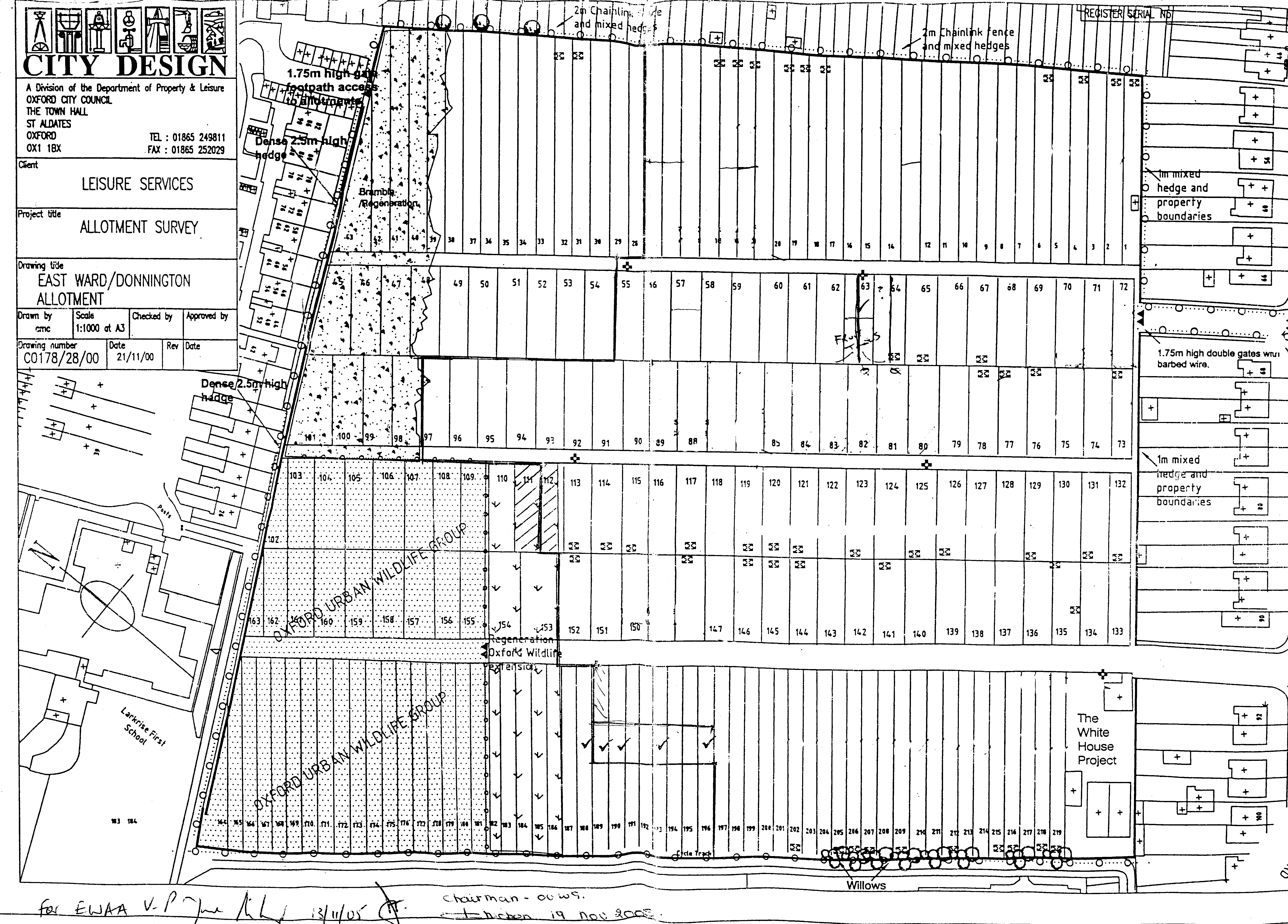
Formal allotments as we know them today were developed and by the 1930’s covered the complete area bounded by Cricket Road from the Boundary Brook beside Florence Park to Howard Street, thence up to Iffley Road, along to the Boundary Brook and so back to Cricket Road. It was divided into 4 roughly equal sections separated by an open ditch running down the middle and across into the Boundary brook opposite Campbell Road.
Allotment cultivation came into its own in the Second World War, and all the plots continued in use well after hostilities ceased. An aerial ‘photo of Donnington School in 1958 (pages 54-55 of The Changing Faces of Florence Park) clearly shows allotments in good order right up to Iffley Road and the Brook.
There was no mains water. Some of those near the brook cut steps down to collect water from it. One enterprising fellow with a plot bordering the middle ditch, rigged up a hand pump to get what water he could from it. Many worked on their plots late into the summer evenings, the sweet smell of bonfires wafting across, but no one complained! There was always plenty of activity.
In the 1960’s many of the plots fell into disuse and the Council had their eyes on the area for housing. A new experimental government scheme was on offer which would have included new roads from both Cricket Road and Iffley Road. However, decision-making was slow and the scheme was moved elsewhere.
This left the City with a large area to develop. The north-west quarter was to remain as allotments (the ground we have today). The highest and driest part to the south-west to be used for housing, so the Boundary Brook estate was built. Next to it Larkrise first school, with playing fields stretching across to the brook. These playing fields were then made available to Donnington School via a new side gate and bridge. The bottom south-east section, the lowest and wettest, was taken up with a new school for Cowley St. John, replacing the old single-sex premises in Cowley Road. Building began in the early 1970’s. As the same time, the open drainage ditches were replaced with covered culverts forming the raised path alongside the cycle track. As this was above the level of surrounding ground the new school playing field area was in-filled to raise the level to that of the new covered culverts.
In recent years more plots have fallen into disuse and further inroads have been made into the cultivated area. One end is now managed by the Urban Wildlife Trust as a nature reserve. The Whitehouse Nurseries occupies former plots beside the shop. A play area for the children of younger gardeners, as well as picnic/barbeque facilities, can now be found on the middle road.
Hopefully these additions will encourage more folk, families, young and not so young, to take up cultivation and produce food for themselves at the same time as getting the benefit of the open air. Let’s hope that this little area of Oxford will remain as an open space for future generations to enjoy.
Colin Gammon (Plot 141, EWAA Member since 1994)